Monitoring the growth and distribution of our coastal estuary vegetation, marshes, mangroves, and seagrass beds, is an important component of the Reserve’s stewardship and land management efforts. Another critical measurement is the sinking or gaining of elevation of these habitats in relation to sea level rise. Understanding how estuary habitats can “keep up” with sea level rise is an essential coastal management question. Not only is the health and wellbeing of coastal habitats important to the natural ecosystem, it is important to the thriving human communities and economies that depend on them.
National Estuarine Research Reserves (NERRs) around the country have been monitoring elevation change for a number of years, including here at Mission-Aransas. Surface Elevation Tables (SETs) are the go-to tools used to conduct precise measurements of the height of the sediment surface and are used to monitor whether the particular area is sinking or gaining elevation over time. Used collectively across an estuary, SETs can identify patterns to determine how resilient marsh, mangrove or other valuable estuary habitats are to sea level rise.
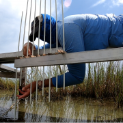
SETs are essential monitoring tools because they are relatively easy to install and use, are non-destructive to the habitat, and can provide reliable, long-term data. SETs are comprised of three components: (1) a long stainless steel rod, (2) a SET arm, and (3) SET pins. The rod is driven deep into the ground (30+ feet), then the SET arm or benchmark bar is attached onto the top of the rod and runs parallel to the sediment surface. The SET pins are inserted through the arm, and lowered to the sediment surface to measure the elevation levels. Processes at the surface of the sediment and below the ground influence the elevation measured by the SETs, such as compression of the sediment due to extended droughts or accumulation of sediment from nearby river input.
In a recent NERR System Science Collaborative publication, a team of 15 Reserves, including Mission-Aransas, worked to develop tools to process, analyze, and communicate SET data collected across the NERR System. In addition to the tools, the project generated the first synthesis of SET data from multiple reserves. The data and tools will be utilized not only by land managers and stewardship coordinators, but by coastal training and education staff to communicate the resiliency of our nation’s estuaries in the face of climate change and other factors influencing habitat elevation. Nationally, the synthesis revealed a mix of “rising and sinking” estuaries across all three coastlines. Estuaries where sediment growth outpaced the rise in sea level and those that are slowly “drowning” as their sediment sinks or fails to accumulate faster than the rate of rising sea levels.
Mission-Aransas Reserve has been monitoring SET data since 2013 and currently has 18 SETs installed in marsh and mangrove habitats. SET data is collected twice a year, accumulating to tell a story of diverse resilience to a changing climate. Mud Island East was highly impacted by Hurricane Harvey, limiting data collection and a reliable measurement of elevation. Goose Island is a healthy marsh, with sediment accumulation keeping pace with sea level rise. Aransas National Wildlife Refuge while accumulating sediment is still “drowning” as it falls behind the rate of sea level rise. As with all good long term monitoring projects, the science is telling the story and there are many more interesting discoveries to be made.
About the author: Kristin Evans is the Education Coordinator for the Mission-Aransas Reserve overseeing education and outreach programs for K12 and public audiences, including our two public interpretive centers the Bay Education Center in Rockport and the Patton Marine Science Center in Port Aransas.

